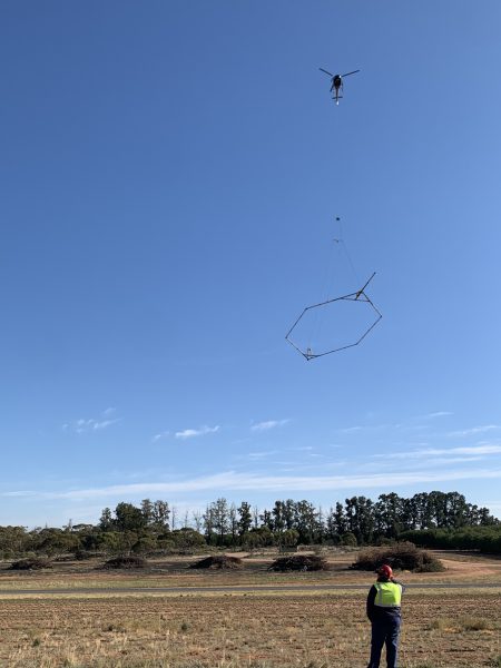
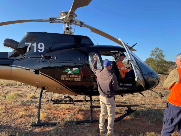
In recent months, residents of the Mallee region witnessed an uncommon sight: a helicopter flying overhead, equipped with a large, peculiar-looking wire vessel. Constructed by boat builders in Germany, with aerodynamics to match, the apparatus resembles a giant hexagon – a sleek yacht of the sky, if you will. This unique setup is part of an ambitious and critical project—the Mallee Salinity Survey—designed to capture data which can assist in mapping salinity levels across the Mallee’s Murray River corridor, essential for managing one of the region’s most pressing environmental challenges.
The survey utilised airborne electromagnetic technology to capture this data. This represents a significant investment in understanding and combating salinity in the Mallee, a region renowned for its $1.3 billion irrigated horticulture sector. By collecting detailed data on groundwater, as well as assessing the potential for salt mobilisation, the survey will inform decisions on salinity management at a regional scale. This data is crucial for fulfilling the Mallee Catchment Management Authority’s (CMA) legislative obligations concerning salinity management.
The Sequana team, led by Project Manager Dan Nolan, was engaged by Mallee CMA to providing project management support and contract advice to ensure the important survey – which covered more than 21,500 km of flight lines over an area of more than 4000km2 – could be delivered in the most effective and efficient way possible. Ultimately, through exemplary management of the survey, it was completed ahead of schedule, with the results to inform salinity management for the next 20 years.
Understanding Salinity in the Mallee
“Salinity is a naturally occurring part of the Mallee landscape, but it has implications for both the environment and agriculture,” Dan Nolan explains.
“If we go back millions of years, the ocean actually covered Mildura – which is hard for us to imagine today – over time, the water receded, but salt remained in the soil and in the groundwater.
“High salinity levels can devastate crops, degrade soil quality, and harm native vegetation and water quality. The Mallee Salinity Survey is a proactive effort to gather the most up-to-date information to inform how salinity can be managed now and into the future,” he continued.
The survey, which uses non-invasive airborne electromagnetic (AEM) technology to collect data from up to 40 metres below ground, will help improve the understanding of how salinity is affecting the region and inform ways to better manage it.
The Role of Sequana
While undertaking AEM surveys is not a new concept for the Mallee CMA, it’s the first time Sequana has been engaged to project manage the data collection.
Sequana has been actively engaged with Mallee CMA, setting the project up for success, with our involvement including:
- Review of the Detailed Design and providing advice to the Mallee CMA on how to go to market to secure a Principal Contractor
- Tender Management, Contract Negotiations and offering contract advice to set the contract up
- Project Management and contract management advice during delivery
- Working closely with contractors and technical advisors to understand the nuances of geophysics and hydrogeology so that all parties understand what the final products are which will be produced
Collecting and analysing this data is no small feat. The project has faced several challenges, including a 12-month delay due to the floods, with the Sequana team playing a pivotal role in navigating these and other challenges. From advising on the initial contract setup to managing the project through to its completion, the collaborative efforts of all involved parties have been crucial to the project’s success.
Community Engagement and Long-Term Benefits
A critical component of the Mallee Salinity Survey’s success has been the community engagement. Covering more than 4,000km2, extensive communication with communities across the region was required to ensure everyone was informed and understood the purpose of the survey. Mallee CMA, supported by Sequana, ran an information day where people could see the helicopter, receiving great feedback from the community on this, as well as the easy-to-understand communication products developed.
The importance of community engagement cannot be underestimated, as Dan Nolan explains.
“It’s the years of detailed investigations and strong relationships with the Mallee CMA that have laid the groundwork for this project. The data collected will not only help protect the environment but will also support the region’s agricultural sector, ensuring that the land remains productive and sustainable for future generations.”
Looking to the Future
The final data from the Mallee Salinity Survey will provide the Mallee CMA with critical insights into salinity and groundwater trends at a regional scale. This information will guide efforts to protect the environment, safeguard agricultural productivity, and meet legislative requirements. By understanding how salinity is impacting the landscape and how it may change in the future, the Mallee can take proactive steps to mitigate these effects and preserve its natural resources.
The 2024 Mallee Salinity Survey is a testament to the power of technology and collaboration in addressing environmental challenges. As the Mallee CMA prepares to analyse the data and plan future salinity management, the region can look forward to a future where salinity is managed more effectively, benefiting both the environment and the local economy.